✨ New Arrivals Just Dropped!Explore
1 / 2
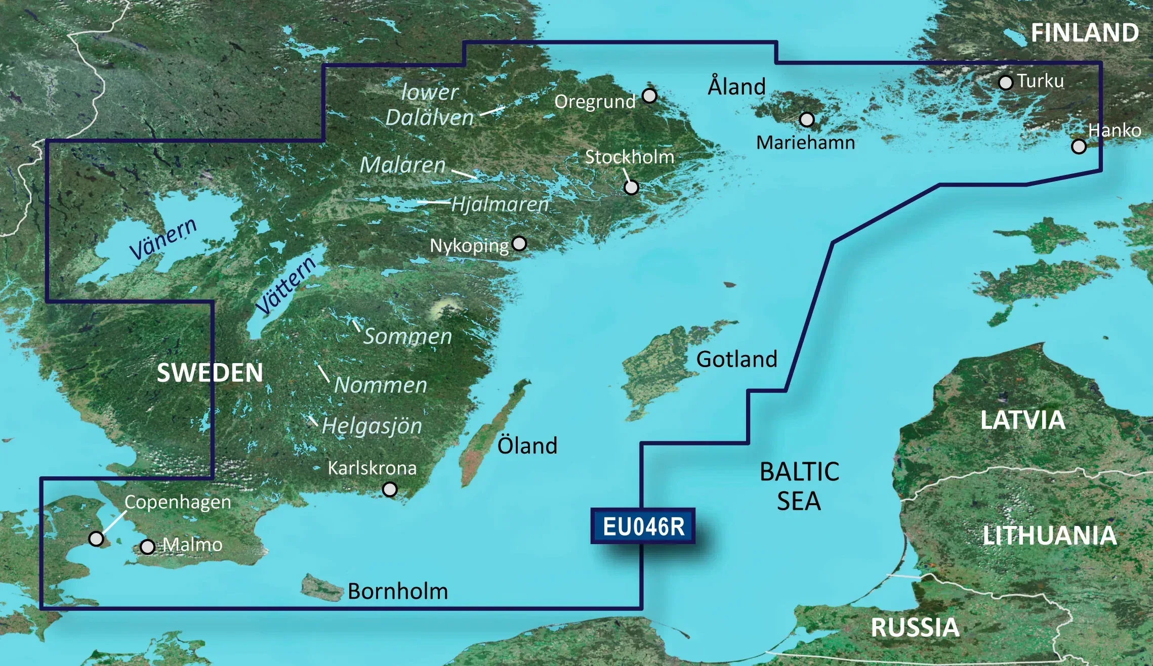
Garmin BlueChart g3 HD HXEU046R South-East Sweden Chart
The clearest, most extensive, and most detailed new charts available, with integrated Garmin and Navionics® contents. The automatic guidance system calculates routes quickly, based on the specified depth and clearance.
See the target depth with a single glance, due to the shading for up to 10 depth ranges. The fishing charts are detailed, as the surface profile of the bottom is shown with an accuracy of up to 30cm (1 foot). Using the shallow water shading feature, the user can specify the shading depth and thus avoid shallow areas Receive extensive and accurate details while on the water. The BlueChart® g3 charts are the clearest, most extensive, and most detailed ones available.
Auto Guidance Technology
The Auto Guidance feature¹ calculates a suggested route using your desired depth and overhead clearance.
Depth Range Shading
This feature displays high-resolution Depth Range Shading for up to 10 depth ranges, so you can view your designated target depth.
Shallow Water Shading
To aid in navigation, Shallow Water Shading allows map shading at a user-defined depth to give a clear picture of shallow waters to avoid.
Detailed Contours
BlueChart g3 charts feature 1’ contours that provide a more accurate depiction of bottom structure for improved fishing charts and enhanced detail in swamps, canals and port plans.
• Realistic navigation features showing everything from shaded depth contours and coastlines to spot soundings, navaids, port plans, wrecks, obstructions, intertidal zones, restricted areas, IALA symbols and more.
• Smooth display presentation including seamless transitioning between zoom levels and more continuity across chart boundaries.
• Safety Depth settings lets you select up to five values for specific depth contour intervals.
• Fishing charts to help scope out bottom contours and depth soundings with less visual clutter on the display.
• Choice of standard 2D direct overhead or 3D over the bow map perspective to make chart reading and orientation easier.
• Compatible with the HomePort™ software. The software allows you to use BlueChart data to plan and organize routes on a computer before your trip
Delivered on a microSD card (SD adapter included)
Features:
• Realistic navigation features showing everything from shaded depth contours and coastlines to spot soundings, navaids, port plans, wrecks, obstructions, intertidal zones, restricted areas, IALA symbols and more.
• Smooth display presentation including seamless transitioning between zoom levels and more continuity across chart boundaries.
• Safety Depth settings lets you select up to five values for specific depth contour intervals.
• Fishing charts to help scope out bottom contours and depth soundings with less visual clutter on the display.
• Choice of standard 2D direct overhead or 3D over the bow map perspective to make chart reading and orientation easier.
• Compatible with the HomePort™ software. The software allows you to use BlueChart data to plan and organize routes on a computer before your trip
$140.84
Garmin BlueChart g3 HD HXEU046R South-East Sweden Chart—
$140.84
Product Information
Product Information
Shipping & Returns
Shipping & Returns
Description
The clearest, most extensive, and most detailed new charts available, with integrated Garmin and Navionics® contents. The automatic guidance system calculates routes quickly, based on the specified depth and clearance.
See the target depth with a single glance, due to the shading for up to 10 depth ranges. The fishing charts are detailed, as the surface profile of the bottom is shown with an accuracy of up to 30cm (1 foot). Using the shallow water shading feature, the user can specify the shading depth and thus avoid shallow areas Receive extensive and accurate details while on the water. The BlueChart® g3 charts are the clearest, most extensive, and most detailed ones available.
Auto Guidance Technology
The Auto Guidance feature¹ calculates a suggested route using your desired depth and overhead clearance.
Depth Range Shading
This feature displays high-resolution Depth Range Shading for up to 10 depth ranges, so you can view your designated target depth.
Shallow Water Shading
To aid in navigation, Shallow Water Shading allows map shading at a user-defined depth to give a clear picture of shallow waters to avoid.
Detailed Contours
BlueChart g3 charts feature 1’ contours that provide a more accurate depiction of bottom structure for improved fishing charts and enhanced detail in swamps, canals and port plans.
• Realistic navigation features showing everything from shaded depth contours and coastlines to spot soundings, navaids, port plans, wrecks, obstructions, intertidal zones, restricted areas, IALA symbols and more.
• Smooth display presentation including seamless transitioning between zoom levels and more continuity across chart boundaries.
• Safety Depth settings lets you select up to five values for specific depth contour intervals.
• Fishing charts to help scope out bottom contours and depth soundings with less visual clutter on the display.
• Choice of standard 2D direct overhead or 3D over the bow map perspective to make chart reading and orientation easier.
• Compatible with the HomePort™ software. The software allows you to use BlueChart data to plan and organize routes on a computer before your trip
Delivered on a microSD card (SD adapter included)
Features:
• Realistic navigation features showing everything from shaded depth contours and coastlines to spot soundings, navaids, port plans, wrecks, obstructions, intertidal zones, restricted areas, IALA symbols and more.
• Smooth display presentation including seamless transitioning between zoom levels and more continuity across chart boundaries.
• Safety Depth settings lets you select up to five values for specific depth contour intervals.
• Fishing charts to help scope out bottom contours and depth soundings with less visual clutter on the display.
• Choice of standard 2D direct overhead or 3D over the bow map perspective to make chart reading and orientation easier.
• Compatible with the HomePort™ software. The software allows you to use BlueChart data to plan and organize routes on a computer before your trip
See the target depth with a single glance, due to the shading for up to 10 depth ranges. The fishing charts are detailed, as the surface profile of the bottom is shown with an accuracy of up to 30cm (1 foot). Using the shallow water shading feature, the user can specify the shading depth and thus avoid shallow areas Receive extensive and accurate details while on the water. The BlueChart® g3 charts are the clearest, most extensive, and most detailed ones available.
Auto Guidance Technology
The Auto Guidance feature¹ calculates a suggested route using your desired depth and overhead clearance.
Depth Range Shading
This feature displays high-resolution Depth Range Shading for up to 10 depth ranges, so you can view your designated target depth.
Shallow Water Shading
To aid in navigation, Shallow Water Shading allows map shading at a user-defined depth to give a clear picture of shallow waters to avoid.
Detailed Contours
BlueChart g3 charts feature 1’ contours that provide a more accurate depiction of bottom structure for improved fishing charts and enhanced detail in swamps, canals and port plans.
• Realistic navigation features showing everything from shaded depth contours and coastlines to spot soundings, navaids, port plans, wrecks, obstructions, intertidal zones, restricted areas, IALA symbols and more.
• Smooth display presentation including seamless transitioning between zoom levels and more continuity across chart boundaries.
• Safety Depth settings lets you select up to five values for specific depth contour intervals.
• Fishing charts to help scope out bottom contours and depth soundings with less visual clutter on the display.
• Choice of standard 2D direct overhead or 3D over the bow map perspective to make chart reading and orientation easier.
• Compatible with the HomePort™ software. The software allows you to use BlueChart data to plan and organize routes on a computer before your trip
Delivered on a microSD card (SD adapter included)
Features:
• Realistic navigation features showing everything from shaded depth contours and coastlines to spot soundings, navaids, port plans, wrecks, obstructions, intertidal zones, restricted areas, IALA symbols and more.
• Smooth display presentation including seamless transitioning between zoom levels and more continuity across chart boundaries.
• Safety Depth settings lets you select up to five values for specific depth contour intervals.
• Fishing charts to help scope out bottom contours and depth soundings with less visual clutter on the display.
• Choice of standard 2D direct overhead or 3D over the bow map perspective to make chart reading and orientation easier.
• Compatible with the HomePort™ software. The software allows you to use BlueChart data to plan and organize routes on a computer before your trip