✨ New Arrivals Just Dropped!Explore
1 / 6
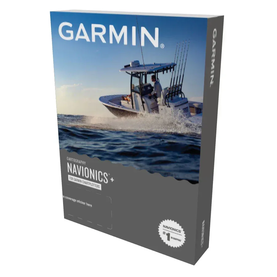
Garmin Navionics+ EU081R Baltic Sea East Coast Charts
You have never seen Garmin maps like this. Presenting the next generation of cartography for Garmin marine devices. Most up-to-date Garmin Navionics+ sea charts for compatible Garmin chart plotters. All-in-one mapping solutions offers detail-rich mapping of coastal features, lakes, rivers and more. Features Include depth range shading, advanced Auto Guidance+ TM, and constantly updated maps using the ActiveCaptain solution. Combining the best of Garmin and Navionics automatic routing features, built-in Auto Guidance+ technology gives you a suggested dock-to-dock path to follow through channels, inlets, marina entrances and more. Different shading options are handy for navigating in shallow waters and finding the best depth range at fishing spots.
• Integrated map contents for coastal and inland waters. Integrated Garmin and Navionics content with a new, redesigned interface that features an updated color palette and Navionics cartography-style appearance. Exceptional coverage, clarity, and details.
• The one-year included subscription gives you access to daily chart updates via the ActiveCaptain smart device app.
• New Navionics® style color palette and layout
• Advanced Auto Guidance+ TM technology. Auto Guidance+ offers faster route calculation and more detailed views compared to the traditional Auto Guidance technology. Auto Guidance+ is for planning purposes only and does not replace safe navigation operations
• High-resolution depth range shading lets you select up to 10 color-shaded options and view your designated target depths at a glance.
Up to 1' contours provide a clear depiction of bottom structure, for improved fishing and navigation. • Shallow water shading aids navigation by allowing for shading at a user-defined depth.
• Community-sourced ActiveCaptain content provides useful POIs, advice, and recommendations from boaters with firsthand experience of the local environment
• Use of Garmin Navionics+ or Garmin Navionics Vision+ requires a compatible chart plotter with the January 2022 software update, which is included on the chart cards. You can also download the update through the ActiveCaptain application or the Garmin Express™ software
Check compatibility here https://www.garmin.com/en-US/marine/chartplotter-compatibility/
$150.29
Garmin Navionics+ EU081R Baltic Sea East Coast Charts—
$150.29
Product Information
Product Information
Shipping & Returns
Shipping & Returns
Description
You have never seen Garmin maps like this. Presenting the next generation of cartography for Garmin marine devices. Most up-to-date Garmin Navionics+ sea charts for compatible Garmin chart plotters. All-in-one mapping solutions offers detail-rich mapping of coastal features, lakes, rivers and more. Features Include depth range shading, advanced Auto Guidance+ TM, and constantly updated maps using the ActiveCaptain solution. Combining the best of Garmin and Navionics automatic routing features, built-in Auto Guidance+ technology gives you a suggested dock-to-dock path to follow through channels, inlets, marina entrances and more. Different shading options are handy for navigating in shallow waters and finding the best depth range at fishing spots.
• Integrated map contents for coastal and inland waters. Integrated Garmin and Navionics content with a new, redesigned interface that features an updated color palette and Navionics cartography-style appearance. Exceptional coverage, clarity, and details.
• The one-year included subscription gives you access to daily chart updates via the ActiveCaptain smart device app.
• New Navionics® style color palette and layout
• Advanced Auto Guidance+ TM technology. Auto Guidance+ offers faster route calculation and more detailed views compared to the traditional Auto Guidance technology. Auto Guidance+ is for planning purposes only and does not replace safe navigation operations
• High-resolution depth range shading lets you select up to 10 color-shaded options and view your designated target depths at a glance.
Up to 1' contours provide a clear depiction of bottom structure, for improved fishing and navigation. • Shallow water shading aids navigation by allowing for shading at a user-defined depth.
• Community-sourced ActiveCaptain content provides useful POIs, advice, and recommendations from boaters with firsthand experience of the local environment
• Use of Garmin Navionics+ or Garmin Navionics Vision+ requires a compatible chart plotter with the January 2022 software update, which is included on the chart cards. You can also download the update through the ActiveCaptain application or the Garmin Express™ software
Check compatibility here https://www.garmin.com/en-US/marine/chartplotter-compatibility/
• Integrated map contents for coastal and inland waters. Integrated Garmin and Navionics content with a new, redesigned interface that features an updated color palette and Navionics cartography-style appearance. Exceptional coverage, clarity, and details.
• The one-year included subscription gives you access to daily chart updates via the ActiveCaptain smart device app.
• New Navionics® style color palette and layout
• Advanced Auto Guidance+ TM technology. Auto Guidance+ offers faster route calculation and more detailed views compared to the traditional Auto Guidance technology. Auto Guidance+ is for planning purposes only and does not replace safe navigation operations
• High-resolution depth range shading lets you select up to 10 color-shaded options and view your designated target depths at a glance.
Up to 1' contours provide a clear depiction of bottom structure, for improved fishing and navigation. • Shallow water shading aids navigation by allowing for shading at a user-defined depth.
• Community-sourced ActiveCaptain content provides useful POIs, advice, and recommendations from boaters with firsthand experience of the local environment
• Use of Garmin Navionics+ or Garmin Navionics Vision+ requires a compatible chart plotter with the January 2022 software update, which is included on the chart cards. You can also download the update through the ActiveCaptain application or the Garmin Express™ software
Check compatibility here https://www.garmin.com/en-US/marine/chartplotter-compatibility/